

The parts before this article described damage already done: the forecast itself, in Hunger Foretold; the rains that failed in Sudan and the belt of countries that failed with it, in El Niño has Landed; the harvests lost in Central and South America, in El Niño Crosses the Atlantic. Asia is different, and the difference is that the El Niño impacts here are still mostly a forecast. The most anomalous dry conditions across Southeast Asia are forecast to run from late September to February. India’s monsoon has weeks left. Vietnam’s salinity season has not started. Indonesia’s worst fire months are ahead. This is where roughly half the people on earth live, and where most of the rice they eat is grown, so a bad harvest will affect the world.
Photo Credit: ©KANPISUT - STOCK.ADOBE.COM
The Rice Belt Is Counting Already
Asia grows the largest grain crop in the world and the one where a shortfall stops being a regional tragedy and becomes a global price hike. Also, as of this month, the impacts of El Niño is no longer entirely a forecast.
India’s southwest monsoon has run short all season, and the shape of the shortfall matters more than the size. June received only 60 percent of the long-period average for rain. July rains then over-corrected to 103 percent, which rescued a great deal of rice plantings that had looked lost. By August 24, the cumulative rain deficit stood at 13 percent, and the season’s first three months finished 14 percent down. The India Meteorological Department now expects September to deliver less than 91 percent of normal rains, which would close the season out at only 90 percent of the long-period average of rain India usually receives.1
That recovery in July is worth dwelling on, because it is the difference between this article and the previous three. Kharif sowing was running 23 percent behind at the end of June. By the end of July, it was 3 percent behind, and by August 17 the gap was down to 1.5 percent. Live monitoring of water storage across 150 major reservoirs reached 64.3 percent of capacity by August 20, well up from the 44 percent at the start of the month. One month of rain undid most of two months of damage. That is what a system with irrigation and reserves can do, and it is precisely what Sudan and Guatemala do not have.2
But the averages hide the story. Rice acreage is still down 3.2 percent with an estimated harvest of 40.5 million hectares. The deficits that persist are in the eastern and northern rice belt, in the sugarcane areas of the west and south, and in the soybean regions, all of which are under moisture stress. The USDA’s Foreign Agricultural Service now expects Indian rice production to be down about 4.5 percent and maize down 9.3 percent. A crop assessment in late August found 32 percent of 446 monitored districts under watch, 15 percent of them for dry risk. Uneven rainfall over a subcontinent is not a smaller problem than uniform drought, it is a differently distributed one, and this one lands on the farmers with the least irrigation to fall back on. Roughly three in five hectares of Indian cropland have no assured access to water.3
The input costs for fuel and fertilizer have moved independently of the weather. Indian fertilizer companies have been importing urea at more than $950 a tonne, compared to $400 to $450 a tonne before the Strait of Hormuz closed in February. The cost of sugar went from 48 to 55 rupees between July 20 and August 20, and the government has permitted duty-free raw sugar imports to ensure that there is enough sugar to meet India’s needs. The phosphate and fertilizer squeeze this publication described in Hunger Foretold, is arriving in the largest agricultural economy in the world at the same moment as a weak monsoon.4
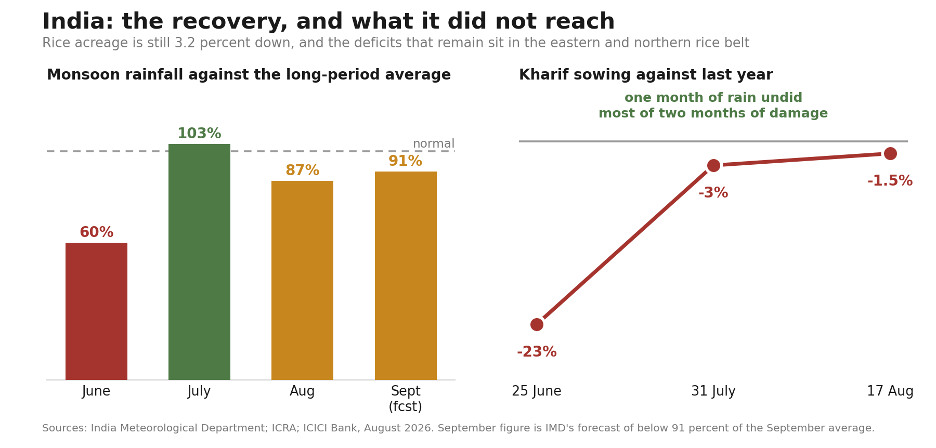
Figure 1. India’s monsoon rescued itself in July and then did not finish the job. June came in at 60 percent of the long-period average, July at 103, and the IMD expects September below 91. Sowing recovered from 23 percent behind last year to 1.5 percent. What the averages hide is where the shortfall sits: rice acreage is still down 3.2 percent, and the deficits that remain are in the eastern and northern rice belt.
The Crop That Has Not Been Planted Yet
The crop that hasn’t been planted is the “rabi” crop, sown from October into December and harvested in spring, and it is mostly wheat. Rabi does not run on monsoon rainfall. It runs on what the monsoon left behind: soil moisture at sowing, and water in the reservoirs to irrigate the rabi crop through the dry winter. Which means the reservoir figure quoted above is not really a kharif number at all. Storage at 64.3 percent of capacity in late August is the opening balance for the winter crop, and it is the number to watch through October as it draws down.
This matters because El Niño winters in northern India tend to be dry, and because wheat, not rice, is what India’s own food security system runs on. The Food Corporation of India’s buffer is a wheat and rice buffer, and wheat is the half that has been tight in recent years. A weak rabi arriving in March 2027, on top of a kharif already down 4.5 percent in rice, is the sequence that produces an Indian policy response rather than merely an Indian harvest problem.
The same is true across the region. Vietnam’s winter-spring rice is planted in November, Indonesia’s main planting begins as the rains arrive or fail, and Afghanistan’s winter wheat is sown from October. None of those crops exists yet. All of them are 2027’s food, and all are still a decision rather than a harvest.
What New Delhi Does Next Is the Whole Question
India controls roughly forty percent of the world’s traded rice. Which means the question for 2027 is not really whether Indian farmers lose yield. It is what the Indian government does about it, and how fast everyone downstream reacts to what India does.
There is a precedent and it is recent. In 2023, a merely moderate El Niño was enough to produce a ban on non-basmati exports within weeks, and rice prices reached fifteen-year highs. The ban was not a response to famine in India. It was a response to a forecast, and to the domestic politics of food inflation. Both of those conditions exist again now, with a considerably stronger event and a urea price more than double what it was in January.
“The mechanism that turns a shortage into a famine is not the weather. It is governments each acting reasonably to protect their own people, in an order that leaves the poorest countries last.”
Watch two things rather than the monsoon totals. The first is the Food Corporation of India’s buffer stock position against its quarterly norms, which are published monthly. The second is the Directorate General of Foreign Trade’s notification channel, which is where the 2023 ban appeared with no warning on July 20. Stockpiling is the observable step before a ban, and it is already happening elsewhere in the region.
The Importers Are Already Buying Rice
That part is no longer hypothetical. Malaysia and the Philippines have been increasing rice purchases to build national reserves ahead of the dry season, and that precautionary demand has moved the market on its own. Thai and Vietnamese benchmark grades have climbed above $400 a tonne, with Thai prices rising $40 to $50 in a fortnight at one point this summer. The Bangkok export price reached $490 a tonne at the end of June, up 27.5 percent since the start of the year.5
This is how 2007 and 2008 began. Not with a harvest failure large enough to starve anyone, but with importers buying early, exporters noticing, and each government reasonably deciding to secure its own supply first. World rice production that year was not short. The price tripled anyway.
Thailand, the second-largest exporter, has had its El Niño warning already. The country received roughly sixty percent less rain than normal between January and April, and the Office of the National Water Resources has said it could face a drought crisis more serious than 2015. Its 2025-26 paddy crop came in at 35.44 million tonnes, with the main crop down slightly and the off-season crop down 1.6 percent, on dry spells and water limits outside the irrigation zones.6
The Delta That Feeds the Importers
This brings us to the country missing from almost every rice story written about this El Niño, including, until now, this one. Vietnam.
Vietnam is where the Philippines buys. Of Philippine rice imports so far this year, 2.59 million tonnes came from Vietnam, compared to 378,404 tonnes from Thailand and 286,052 tonnes from Myanmar. Vietnam is not a minor supplier to the region’s most exposed importer. Vietnam is the supply.
Vietnam has published its own forecast, which almost nobody outside the country has read. The Department of Hydrometeorology, under the Ministry of Agriculture and Environment, expects El Niño to persist with a probability above 95 percent, reaching moderate to strong intensity with a 60 to 65 percent chance of becoming very strong by late 2026 or early 2027. Note in passing that Hanoi’s own agency is more cautious than the WMO on that last point, which is worth remembering the next time a single forecast is quoted as settled.
What the Vietnamese forecast says next is the part that matters for everyone downstream. Southern Vietnam’s rainy season is expected to end in late October or early November, several weeks earlier than usual, particularly across the Mekong Delta. From roughly November through April or May of 2027, the Delta is forecast to face severe drought and saltwater intrusion. During high tides in early 2027, the four grams per liter salinity boundary, the point past which rice will not grow, is projected to push 90 to 125 kilometers up the Vam Co river, 85 to 90 kilometers along the Cua Tieu, and 70 to 80 kilometers along the Ham Luong. That would directly affect more than 350,000 hectares of winter-spring rice, along with fruit-growing areas, aquaculture, and the domestic water supply for millions of people in coastal communities.7
The winter-spring crop is the export crop. It is also the crop that has not been planted. Vietnam’s Department of Crop Production has already instructed provinces in the Mekong Delta and the southeast to plan the 2026-27 winter-spring rice season around water availability, tidal surge and salinity risk, which is to say around a forecast rather than around a harvest. The ministry has published two planning scenarios, one high-risk and one very high-risk, and has distributed them to provincial authorities as preparedness tools.
So, the sentence that follows in the next section of this article, that the Philippines is buying on a market where the largest exporters are short, is not a rhetorical flourish. It is a description of a forecast that the supplying government of Vietnam has already published and already begun planning against.
There is one more thing in the Vietnamese record, and it is the most encouraging fact in this article. During the 2015-16 event, reduced Mekong flows combined with severe saltwater intrusion caused widespread disruption to domestic water, agriculture and aquaculture across the delta. In 2023-24, salinity intrusion was again severe. The losses were considerably lower. The Vietnamese assessment attributes the difference to improved forecasting and earlier response measures. Same river, same ocean cycle, comparable salinity, far less damage, because somebody acted on the forecast in time. That is the entire argument of this series, run as a natural experiment, in the Delta that feeds both Vietnam and the Philippines.8
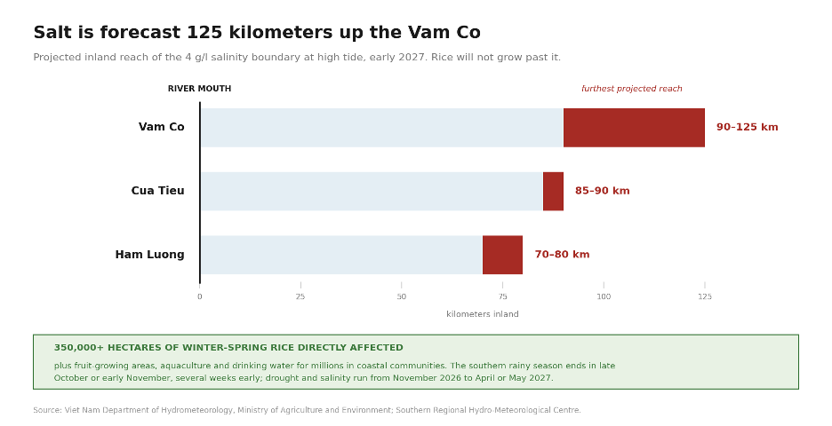
Figure 2. Vietnam’s Mekong Delta salinity forecast for early 2027: the four grams per liter boundary projected 90 to 125 km inland on the Vam Co, 85 to 90 km on the Cua Tieu, 70 to 80 km on the Ham Luong, affecting more than 350,000 hectares of winter-spring rice. The rainy season is expected to end several weeks early, in late October or early November.
The Philippines Has Two Weeks of Rice
If you want to know where in Asia this becomes a hunger story rather than a price story, it is the Philippines.
More than half of Philippine rice land is rainfed, and the irrigation that serves the rest depends on rainfall too. The historical record shows El Niño cutting Philippine rice yields by five to ten percent, and as much as twelve in severe episodes. In April, national authorities warned that fifteen provinces were at risk of severe El Niño-induced drought. The agriculture department expects this event to cost about 700,000 tonnes of “palay”, which is unmilled rice or rice grains still in their husks before processing, putting the projected harvest at between 18.6 and 18.8 million tonnes; some analysts see it falling to 17 or 18 million.9
The Philippines is covering its own rice gap by importing, at a pace that has already passed the whole of last year’s total imports, most of it from Vietnam. The United States Department of Agriculture projects 5.1 million tonnes of imports this year against the Philippine department’s own estimate of only 3.6 to 3.8 million. The two numbers rest on different harvests. USDA’s follows from what it forecasts the Philippines will grow. The Philippines Department’s estimate follows from what the Philippines is planning to grow, a record 20.3 million tonnes of palay. But the same Department has already conceded the smaller harvest is likely as set forth above.The import plan therefore assumes a harvest the Philippines own Department has stopped predicting, and the gap is roughly 1.3 million tonnes of additional rice imports that nobody in the Philippines has yet ordered.10
Behind the import estimates sits the number that should worry anyone reading this. The National Food Authority of the Philippines holds buffer stocks sufficient for only somewhere between seven and fifteen days of national consumption, compared to the thirty-day strategic reserve that is widely treated as the minimum a country should maintain. The Rice Tariffication Law restricts the authority’s capacity to expand those stocks. So, the Philippines enters the driest months of a very strong El Niño with only about two weeks of rice, buying from a Delta that expects salt in its irrigation canals by January, on a market where Thailand, its second supplier, is short, and where India, the largest exporter of all, has banned exports before. That is the whole margin.11
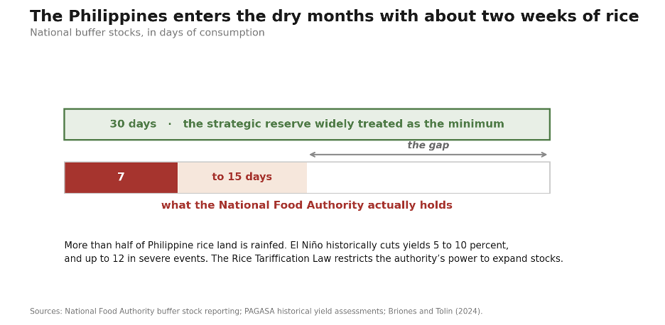
Figure 3. The Philippines enters the driest months of a very strong El Niño holding buffer stocks of roughly one to two weeks against a thirty-day benchmark, importing on a market where the two largest exporters are short and the largest of all has banned exports before.
The Maritime Continent, Where You Can See the El Niño Switch Thrown
There is one region 4Hunger.org has not visited before, and it is the one where the El Niño mechanism actually lives.
In a normal year, the rising branch of the “Walker circulation”, the east–west atmospheric loop that sits over the tropical Pacific, sits over the islands between the Indian and Pacific Oceans: Indonesia, Malaysia, the Philippines, Papua New Guinea. El Niño shifts that rising branch east into the open Pacific, and the Maritime Continent dries. Every other regional impact in these four articles, from Sudan’s failed sorghum to the reservoirs filling in California, is downstream of that single displacement. It is the switch, and it is being thrown now.
Indonesia is already burning. Burned area reached 32,637 hectares by February, twenty times the same period in 2025, and that was before the dry season had properly begun. Satellite thermal detections over mapped peatlands, a proxy for fire activity rather than a count of fires, have totaled 23,546 since January, rising from 5,114 in February to 12,942 in March. Many are inside oil palm and timber concessions.
A positive Indian Ocean Dipole is expected later this year. The dipole is the Indian Ocean’s own version of the same seesaw as El Niño, and its cool pole sits directly off Indonesia, suppressing the convection that brings rain. The Maritime Continent is therefore dried twice over: once by the Walker circulation shifting east, and again by an ocean cooling beneath it. That combination is the signature of the worst fire years on record.12
Peat fires are not ordinary fires. They burn below the surface of the ground; they are close to inextinguishable by rain alone. They produce the transboundary haze that in 1997 and again in 2015 turned into a regional health emergency across Indonesia, Malaysia and Singapore. The 2015-16 event cost an estimated $5 billion in regional losses. In 1997 and 1998, harvests fell by up to 40 percent, with coffee down around 40 percent and palm oil and tea around 30. Roughly 500 people died in Irian Jaya of food shortage and disease.13
Indonesia is Also the 4th Most Populous Country on Earth and Will Need to Import Rice
The fires and the palm oil are how Indonesia usually enters a story like this one, as a source of smoke and a line in a commodity index. It is also the fourth most populous country on earth, and 280 million people there have to eat.
The United Nations’ Asia-Pacific assessment of August 28 named Indonesia as one of the clearest large-area drought concerns in the region. Forecasts show widespread probabilities of below-normal rainfall through September to November, which is precisely the window in which the dry season is meant to end. The main rainy and planting season is meant to begin then too. If El Niño prolongs the dryness or delays the onset of the rains, what suffers is water availability, land preparation for rice crops, and the planting of the country’s main rice crop. Localized crop failures have already been reported across Java, West and East Nusa Tenggara and parts of Sumatra, including damage to rice.14
The same assessment contains the sentence this entire series exists to underline. Vegetation observations do not yet show widespread severe deterioration, which means there is still valuable lead time to monitor soil moisture, reservoirs, irrigation and crop conditions, and to prepare before impacts intensify. That is a United Nations agency saying, in the flat prose of a situation report, that the damage has not happened yet and the interval to prevent widespread damage is open right now.
Indonesia is better placed than most to use this warning and this time. The government projected rice output of 19.3 million tonnes in the first half of this year, holds reserves of around 5.3 million tonnes, and has allocated roughly $3.8 billion to food security measures. That is a state with the fiscal room to act on a forecast. Whether it does, and whether the reserve goes to price stabilization in Java or to the eastern islands where the crop failures are already being reported, is a policy question to be made in Jakarta, and not a meteorological one.
The Palm Oil Lag
Indonesia and Malaysia together produce about 85 percent of the world’s palm oil, which makes this a commodity story as well as a fire one. The Indonesian producers’ association projects that an extreme El Niño could cut national crude palm oil output by as much as five million tonnes, close to 10 percent. But the timing is the point. Prices rise before output falls. Traders are buying on the forecast that the palm oil crop will be short of what is normal, so palm oil already costs more, while the trees themselves are producing normally. The drop in output comes later, starting in the first half of 2027.
That is the same lag this series has described in Sudanese grain stores, in soil phosphate, in the Nile behind Aswan and in the Sudd in South Sudan. Palm is the swing supply in the global vegetable oil market, so a palm shortfall increases demand for soybean oil, which is the mechanism by which a dry season on Sumatra becomes a rise in cooking oil prices in Lagos, Nigeria and Karachi, Pakistan. Malaysia’s own rice production, which is a smaller matter globally but not to Malaysians, is expected to also fall significantly under extreme El Niño conditions. This is part of why Kuala Lumpur has been buying rice, too.
Papua New Guinea sits in the same region and deserves separate mention, because it faces a failure mode nothing else in these four articles has. Its highlands are overwhelmingly home to subsistence farmers, with almost no market buffer, and a strong El Niño brings not only drought but highland frost, which kills the sweet potato gardens the people in the highlands live on. In 2015 and 2016, the government estimated 2.4 million people were affected by these frosts, 1.3 million of them severely, with up to 400,000 in acute food shortage. The World Bank describes Papua New Guinea and Solomon Islands as facing a double catastrophe this year, of Middle East price shocks and El Niño drought together.16
The Countries That Are Not In the Rice Trade
Myanmar has appeared once in this article, as a supplier of 286,052 tonnes of rice to the Philippines. That is the wrong fact about Myanmar. Approximately 12.4 million people there were facing crisis-level food insecurity in May, a figure expected to climb to 20 million or more by mid-year, due to rising food prices and conflict even before El Niño arrives. Myanmar sits inside the FAO’s mapping of agricultural drought risk across South and Southeast Asia, alongside Pakistan, India, Thailand, Cambodia, Vietnam, the Philippines, Indonesia and Timor-Leste. It has the largest hunger caseload of any country in this article and the least capacity to respond to what is coming.17
Pakistan’s “kharif” rice has come in mixed due to delayed monsoon rains, and reduced wheat acreage has created localized pressure. It has also adopted its first national anticipatory action strategy, built on the 2025 Khairpur floods, where acting on a forecast worked. Bangladesh brought in a good “boro” harvest, but boro is the irrigated dry-season crop, and, therefore, the one insulated from a weak monsoon; the rain-fed “aman” crop, harvested in November and December, has yet to be counted.
Cambodia, Laos and Timor-Leste appear in FAO’s drought-risk mapping and almost nowhere else. There is no published El Niño crop assessment or food security analysis for any of them. This is worth noticing rather than passing over: a country with no crop assessment is not a country with no problem, it is usually a country without a monitoring system. Cambodia and Laos are also two of the four most hydropower-dependent economies in the region, which puts them among the most exposed to loss of power due to falling reservoirs and among the least likely to produce data showing it.18
El Niño does not reduce harvests everywhere. Across Afghanistan, where 14 million people face severe food insecurity after four consecutive drought years, the El Niño is expected to drive above-average precipitation countrywide from October 2026 into January 2027. That should enable above-average and timely winter wheat planting, and improve snowpack, contingent on temperatures staying average or below. For the first time in five years, the forecast for Afghan farmers is good news, and it is El Niño delivering it.19
“El Niño is not a random disaster that happens to the world. It is a redistribution of rains that causes drought in some countries and increased rains and floods in others in a pattern that has recurred over 150 years.”
There is also a flood half to this story. The same event that dries the Maritime Continent is expected to bring above-average rain to parts of South and Central Asia, and the International Rescue Committee names Bangladesh, Pakistan and Afghanistan among those countries most at risk of El Niño flooding. Vietnam expects fewer storms in the East Sea but stronger ones. Fewer and worse is harder to plan for than simply more.
The Reservoir Has Three Claimants
Every reservoir in this article appears twice: once as irrigation, and once as something else. That is not a rhetorical device. It is an accounting problem that several governments are about to resolve in public, and the way they resolve it will decide things that have nothing to do with farming.
Hydropower supplies roughly one sixth of Southeast Asia’s electricity, and the systems that lean on it hardest are Cambodia, Laos, Myanmar and Vietnam. Three of these countries have already been discussed in this article as having the least capacity to absorb a reduction in rainfall. During the moderate El Niño of 2023, regional hydropower output fell by 21 terawatt hours against the previous year, and it did so despite 500 megawatts of new capacity coming online. Adding generators does not help when there is no water to turn them.
This year the decline is already measurable. Hydropower generation across key Asian markets fell by about 13 average gigawatts year on year in June, with India and Vietnam accounting for more than eighty percent of the drop. Power systems across the region are burning more coal and liquefied natural gas to hold their grids together. The Philippines precedent from the last event is starker still: available hydroelectric capacity fell to 725.5 megawatts against a dependable 3,472, a decline of eighty percent.20
The timing is what matters here. Analysts expect the acute impacts in early 2027, when depleted reservoirs coincide with the dry-season peak in demand for cooling. That is the same window as the salinity in the Mekong Delta, the same window as India’s rabi harvest, and the year China’s own meteorological agency has named as the one El Niño will hit it hardest. Whatever else 2027 turns out to be, it is the year several kinds of reserve run out at once.
The obvious consequence is emissions: a dash for coal and gas that turns a temporary shortfall into long-lived fossil infrastructure. The less obvious one is why this series cares. Fuel also is an agricultural input. The same governments buying emergency LNG to run air conditioners are the ones whose fertilizer already costs more than double what it did in January because the Strait of Hormuz closed. Bangladesh and Pakistan, both acutely price-sensitive LNG importers, have already curtailed electricity consumption through fuel conservation measures. A government that spends its foreign exchange keeping the lights on in February has less of it to buy urea in March, and less again to buy rice in May.
So when Thailand and Indonesia decide what their reservoirs are for, they are not choosing between farmers and cities. They are choosing between this year’s electricity and next year’s harvest, out of the same water.
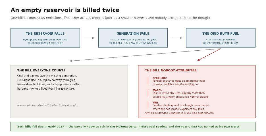
Figure 4. The reservoir empties, the grid buys replacement fuel, and the cost arrives twice. The first bill is counted: coal and gas displace hydropower, and a temporary shortfall hardens into long-lived fossil infrastructure. The second is not. Foreign exchange spent on emergency fuel in February is not available for urea in March, and the smaller planting that follows is recorded, if at all, as a bad harvest rather than as a consequence of the drought.
China Is Forecasting Its Own 2027
China grows more rice than any other country, imports enough to move the world price when it chooses to and has published one of the most specific national El Niño forecasts anywhere. China is also the only government in these four articles to predict that 2027 will be its own worst year in writing.
Start with what Beijing thinks the ocean is doing, because the Chinese agencies did their own analysis with their own instruments. The National Climate Center reports the sea surface temperature index in the El Niño monitoring region at 2.09 degrees in July and averaging 2.59 degrees in August, both the highest readings for those months since records began in 1951. Chen Lijuan, the center’s chief forecaster, says the event is developing unusually quickly and expects it to peak around November or December, potentially as the strongest El Niño on record. In July, the Ministry of Natural Resources’ National Marine Environment Forecasting Center had already warned that warming in the central and eastern equatorial Pacific was running ahead of the 1997-98 event at the equivalent stage. Three Chinese agencies, monitoring separately, made the same prediction as the WMO and NOAA.21
What they forecast next is the opposite of almost everything else in this article. Asia’s El Niño story so far has been a drought story. China’s is a flood story, and it arrives in phases, because ocean heat takes months to work its way through atmospheric circulation. Through this autumn, rainfall is expected above average along and south of the lower Yangtze and across South China, with parts of the southwest at risk of extreme localized rain, while temperatures in the southwest and south run significantly above normal and heat waves are likely. Through the winter, as the event matures, most of the country should be warmer than usual, though forecasters warn that temperatures could still swing sharply as cold air masses push south. Taken on its own, none of that is a catastrophe.
Then comes the sentence that should have been in this article from the beginning. China’s climate in the summer of 2027, the National Climate Center says, will be more severely affected by El Niño than in 2026. The lag is the whole point: the western Pacific subtropical high is expected to strengthen and shift south, dragging moisture into central and eastern China months after the ocean has begun to cool. The middle and lower reaches of the Yangtze are forecast for particularly heavy precipitation and a heightened risk of widespread, severe flooding. Major grain-producing areas in the Northeast and North China are told to prepare for above-average rainfall and floods that could damage crop production. Northwest China and Xinjiang go the other way, into drought driven by unusually high temperatures and limited rain. Authorities have been warned to watch for crop diseases and pests encouraged by warm, humid conditions.
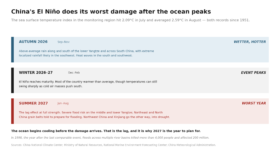
Figure 5. China’s El Niño arrives in phases and does its worst damage after the ocean has peaked. Autumn 2026: above-average rain along and south of the lower Yangtze and across South China, with heat waves in the south and southwest. Winter 2026-27: warmer than normal, with sharp swings as cold air pushes south. Summer 2027: the lag effect at full strength, heavy rain and flood risk on the middle and lower Yangtze and across the northeastern grain belt, drought in the northwest and Xinjiang.
The precedent the Chinese agencies keep returning to is not 2015. It is 1998, the year after the last comparable event, when abnormal rainfall produced floods across multiple river basins, the worst of them on the Yangtze. More than 4,000 people were killed and 200 million affected. The National Marine Environment Forecasting Center expects abnormally high precipitation in the Yangtze basin again in the summer of 2027, with severe pressure on flood control.22
Every other government in these articles is being asked to act on a forecast of this season. China has published one for eighteen months out, named the basins and the crops where El Niño impacts will be severe, and told its provinces to prepare. Nobody in Beijing will be able to say afterwards that the warning came too late.
What the El Niño Predictions for Asia Add Up To
This article has gone country by country, which understates the total. Here is the total as the institutions have published it.
FAO’s analysis of 41 years of satellite imagery finds that a comparable El Niño produced losses of around 15 million tonnes of rice across Southeast Asia. The World Bank has warned that if the event develops fully, rice yields could fall by a fifth to a half across the hardest-hit parts of South Asia, where rice underpins food security for hundreds of millions of people. Those are the numbers that belong at the top of any Asian El Niño story, and they are conspicuously absent from most of them.23
One omission belongs on a watch list rather than in these totals, and it is disease. El Niño reshapes the epidemiology of dengue, malaria and heat illness, and it does the same for crops and livestock: drought-stressed maize carries aflatoxin, so a harvest can exist and still not be safe to eat. It deserves its own article, and 4Hunger.org intends to give it one.
There have been near-record rice harvests in Cambodia, China, Indonesia, Thailand and Vietnam which have built a genuine cushion, and Chinese food prices have been falling on adequate supply. But those are the harvests already in, gathered before this El Niño peaked, and the same assessment warned that surging input costs threaten the next planting cycle. The cushion is real, and it is a cushion against one bad season rather than two.
The Window That Is Still Open
In June, the FAO and the World Food Programme launched a $202 million appeal to protect 8.8 million people across 22 high-risk countries, many of them in this region, before the harvests failed rather than after. As part two of this series recorded, neither agency will say how much of it has been raised, and the only published delivery figure covers six countries and half a million people.
The ocean is running ahead of the forecasts. The Multivariate ENSO Index, which folds sea surface temperature, air pressure, winds and cloud into a single figure and so measures whether the atmosphere has actually coupled to the ocean, stood at 2.41 for June and July. That is the highest June to July value since records began in 1979. Fifteen models now put the Niño 3.4 anomaly at or above 3 degrees for October to December, beyond the top of the scale forecasters normally use, and the mid-August assessment found little sign of any transition away from El Niño before the spring of 2027.24
The forecast has hardened even more. On September 3, the World Meteorological Organization said El Niño was firmly established in the central and eastern equatorial Pacific and would strengthen to very strong before peaking at the end of the year, with a probability approaching certainty that it persists through December to February. It also forecasts a positive Indian Ocean Dipole, the dipole mode index averaging 0.9 degrees over September to November. That is the combination that dries the Maritime Continent hardest, and it is now the expectation rather than only a risk. The next report is the ASEAN Meteorological Centre’s October to December outlook, due in early October.25
What Is Fixed and What Is Not
The El Niño cannot be stopped. The heat is already in the ocean. NOAA measured subsurface anomalies of ten degrees at depth in July, and nothing any government does between now and February will change the temperature of the Pacific. Anyone suggesting otherwise is selling something.
The rain, though, is genuinely uncertain, and this article contains its own proof. India’s monsoon looked like a catastrophe at the end of June and something close to a near-miss by the end of July, and the recovery was large enough to pull sowing back to within two percent of last year. That recovery was not simply luck. The same Indian Ocean Dipole that dries Indonesia warms the Arabian Sea and tends to strengthen the Indian monsoon, so the two teleconnections are statistical linkages by which an ocean anomaly in one basin shifts rainfall in another. The ocean warming in one place changes the weather in another. But these connections only make things likelier, not certain, and so it could make things worse, but sometimes they break the good way, too. They could pull on India in opposite directions, and the season turns on which of them prevails. Afghanistan is about to find that out in the opposite direction from everyone else. Planning on that is not a strategy. Assuming the outcome is already fixed is just as wrong.
Indonesian peat is the clearest case. Once it catches fire, it burns below the surface and rain barely touches it. Canal blocking and rewetting work only before ignition, and the worst fire months are ahead. That is a thing which is cheap in prevent in September and impossible to put out in December.
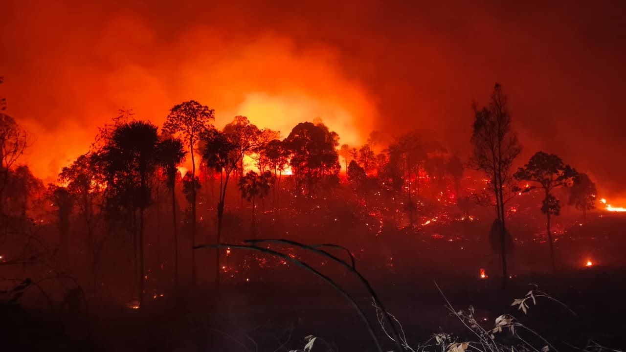
Photo Credit: Niken D. Sitoningrum, Mongabay
Vietnam’s winter-spring planting decisions in the Mekong Delta are being taken now, against a salinity forecast the government has already published, and the 2023-24 season proved what taking them early is worth. Philippine dry-season planting decisions have not all been taken, and the drought-tolerant seed the agriculture department is distributing now sets the yield in March. Indonesia has reserves of 5.3 million tonnes and a choice about where they go. India’s rabi wheat goes in the ground from October on reservoir water that is being allocated this month. Beijing will decide what its reserves will be used for before the Yangtze rises in 2027, but not after. Thailand and Indonesia are about to decide whether their reservoirs serve irrigation, hydropower or drinking water; Panama made that call a year early, which is why it still has a working canal.
And the largest lever of all costs nothing. If India does not ban rice exports, that is worth more to global food security than every anticipatory action budget in this article combined. It is not a question of money or capacity. It is a political choice, and it is still unmade.
So, the honest position is this. El Niño is fixed. The rainfall is uncertain. The response is open, and the record is not encouraging. Southern Africa was warned of a bad harvest a year ahead in 2015 and again in 2023, but the money still arrived after the harvest failed both times. Preventable is a claim that works in something like physics. It has never yet been a reliable predictor of human behavior.
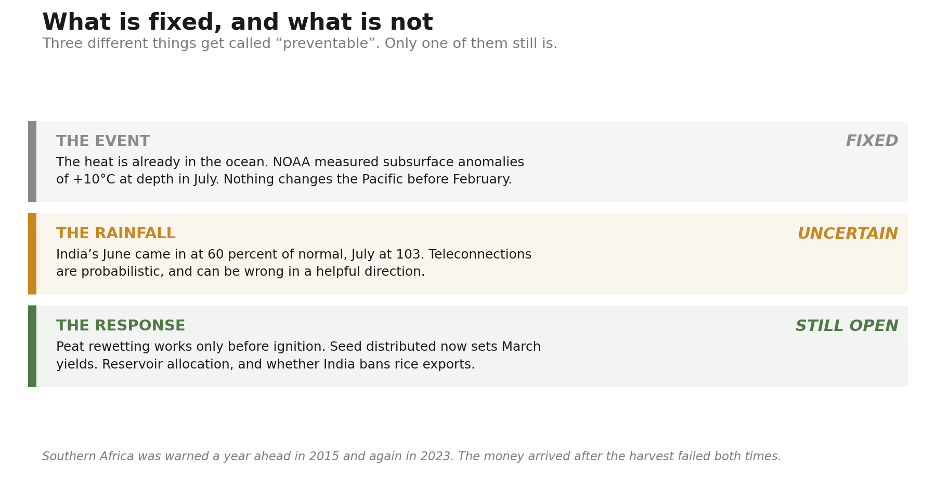
Figure 6. Three things get called preventable and only one of them is. The event is settled physics; the rainfall is genuinely uncertain; the response is open, and it is the response that decides how many people go hungry.
The rains that failed in Sudan failed in July. The primera in Guatemala is gone. Asia is the one place in these four articles where the political decisions that determine the outcome of global hunger are still, for a few more weeks, in front of the people who have to make them.
“This is the part of the map where the warning has arrived before the damage. It will not stay that way for long, and the record of the last five events is that the money needed to prevent hunger arrives after the harvest fails, every time. Let’s hope that the 2026/2027 El Niño is different.”