

The first two parts of this series followed El Niño across Sudan and the belt of countries around it, where it takes rain away from people who have nothing to fall back on. This part follows the same ocean west, and the story changes shape. In Central America’s Dry Corridor, a farming system built around a second chance is losing both chances in the same year. In Panama, the damage arrives as a shipping constraint rather than a harvest. And in the United States, this El Niño is mostly good news: rain for the Southwest, snow for the Sierra, a quieter hurricane season. The hunger it causes in North America will not come from a failed crop. It will come from a price and a policy.
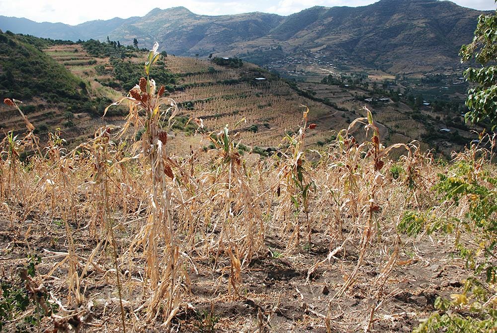
Photo Credit: WFP/ Stephanie Savariaud
Where the Name “El Niño” Came From
In the nineteenth century the fishing crews working out of the northern Peruvian ports noticed that every few years, around Christmas, the cold water they depended on gave way to something warm pushing down from the north. The anchoveta went with it. The nets came up empty and stayed empty for a season. They called the current El Niño de Navidad, the Christ Child, for the time of year it arrived. The warm water also pushes the surviving shoals deep and south, so what the fleet does find is undersized. That is why Peru suspended the season in May: too much of the catch was juveniles.
They were not naming a global phenomenon. They were naming a thing they had to plan around, in the way Central American farmers named the canícula after the dog days of Sirius. Working words, given by people who needed to know when the weather would turn against them.
The science came from a famine.
In 1877 the monsoon failed over India and millions died. The government asked its new meteorological department to forecast the rains. In 1904 the department went to Gilbert Walker, a mathematician appointed because predicting a monsoon was a statistical problem nobody had solved. Walker spent twenty years correlating air pressure from stations around the world, looking for anything that would tell him a year ahead whether India would eat. He found a seesaw in pressure across the Pacific and called it the Southern Oscillation.1
It took until the 1960s for Jacob Bjerknes to show that Walker’s atmospheric seesaw and the fishermen’s warm current were one thing: a single coupled system of ocean and air, and the largest source of year-to-year climate variation on earth.
The forecasts this series keeps quoting exist because of a famine and were built by a man trying to see the next one coming. That is worth holding onto as this article crosses the Americas, from the Guatemalan smallholder who has lost the first of two harvests, to the reservoirs filling in California, to the Peruvian fishery the whole thing is named after, which is failing again.
A System Built Around a Second Chance
Central America’s Dry Corridor is a belt of dry tropical forest running down the Pacific side of the isthmus, from southern Mexico to Panama, in the rain shadow of the mountain chain along its spine. Moisture comes off the Caribbean, drops on the eastern slopes and arrives on the Pacific side already spent. The result is a strip of semi-arid land in an otherwise humid region, farmed almost entirely by smallholders growing maize and beans for themselves to eat. It is built around a second chance. The primera goes in with the first rains in May and June and is harvested in August and September; the postrera follows, sown from September and harvested in November and December. Between them sits the “canícula”, the midsummer dry spell that pauses the rains for a few weeks in July and August. A household that loses the primera can still eat off the postrera. That is the design.
It is also what makes 2026 different, because both halves of this system are failing at once.
The primera is already gone in the worst-affected areas. Between June 20th and July 20th, much of Guatemala’s Dry Corridor recorded only five to eight days with any rainfall at all, and the maize went into stress and began wilting. FEWS NET attributes the damage directly to El Niño conditions and an extended canícula, and places the poorest households of the Dry Corridor in Crisis through September, along with targeted areas of Alta Verapaz in the north and the Western Highlands along the Mexican border. Neither of those lies inside the corridor. Alta Verapaz is cloud-forest country, normally among the wetter parts of Guatemala; the Highlands are volcanic, above two thousand meters, and largely indigenous. That the damage has reached both means it is landing on households already food-insecure for reasons that have nothing to do with rainfall.
In Honduras, cumulative rainfall deficits of around forty-five millimeters were recorded across parts of Yoro, El Paraíso and Olancho in May and June, and roughly 8,800 hectares of maize and 3,100 hectares of red beans have been written off. El Salvador’s small and medium producers expect the first harvest of basic grains to come in around twenty percent down.2
The postrera, the second chance, is being sown now into the same dry conditions. FEWS NET expects widespread delays and reduced planted area across Honduras and El Salvador, because the primera harvest ran late, because soil moisture during the July and August planting window was inadequate, and because fertilizer prices have made the inputs unaffordable. There is another contributing factors, the 2026 hurricane season is forecast to be below average, which is itself an El Niño effect. In most years tropical moisture from tropical storms and even hurricanes is what refills the corridor between seasons. This year the thing that usually rescues the postrera has been suppressed by the same ocean that killed the primera. 3
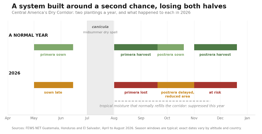
Figure 1. The Dry Corridor plants twice a year so that one failure is survivable. In 2026 the primera was sown late and lost, and the postrera is going in delayed and on reduced area. The tropical moisture that normally refills the corridor between seasons has been suppressed by the same El Niño. Season windows are typical; exact dates vary by altitude and country.
“A two-season system exists so that one failure is survivable. Central America is losing both halves of it in the same year, to the same ocean.”
Meanwhile the lean season arrived early. In Guatemala’s Dry Corridor it began in February rather than the usual June, because households came into the year with no staple grain reserves after consecutive poor harvests. FEWS NET describes an early and prolonged lean season, with the poorest households already selling productive assets, the tools and animals that produce next year’s food, to buy this month’s food. Between two and two and a half million Guatemalans were projected to need food assistance between June and August. 4
The prices tell the rest. White maize in Honduras stood almost 31 percent above last year in June, and more than 35 percent above the five-year average, in a country whose poorest households were already buying rather than growing most of what they eat. Transport costs are running some 15 percent above last year. The Honduran government has placed close to eighty percent of the country under alert, and both El Salvador and Panama have declared formal El Niño alerts. 5
There is a precedent for what follows, and it is recent enough that some readers will remember the news coverage without ever having connected it to the weather. The 2015 and 2016 El Niño left about 3.5 million people across Guatemala, Honduras, El Salvador and Nicaragua needing humanitarian assistance. It also contributed to one of the largest northward migration waves in the region’s modern history, and the largest share of it came out of the Western Highlands, the same volcanic departments FEWS NET has just placed in Crisis. 6
That is worth stating plainly, because it is the point at which this article stops being about somewhere else. A family that loses the primera, then loses the postrera, then sells the animals, has run out of things to sell. What it does next is leave. The United States has spent a decade arguing about immigration and comparatively little time on taking protective actions before the El Nino that we have known is coming for months.
The Corridor Is Seven Countries, Not Three
It is worth being precise about how much country the failed rain covers, because the Dry Corridor is usually written about as though it meant three places. It runs from southern Mexico through Guatemala, El Salvador, Honduras and Nicaragua into Costa Rica, with dry zones reaching Panama. Nicaragua is the hardest of them to see, and that is itself the finding: it sits squarely in the corridor, it was one of the four countries behind the 3.5 million refugees figure in 2015 and 2016, and there is less independent monitoring in Nicaragua than in its neighbors. When the impacts of this El Niño are counted up, Nicaragua is the country most likely to be undercounted.
Panama, Where the Damage Becomes a Freight Rate
Panama is being hit in an entirely different way, and it is the one that will reach a North American checkout counter fastest. To see why, it helps to know that the Panama Canal does not run on sea water.
Unlike Suez, which is a ditch at sea level, Panama lifts ships about eighty-five feet over the Isthmus of Panama and lowers them down the far side. The lifting is done by filling and draining lock chambers from Gatún Lake, a rainwater-fed reservoir that also supplies drinking water to much of Panama’s population. Every ship that crosses the canal uses roughly fifty-two million gallons of that fresh water, and most of it runs out to the sea and is gone. The canal is the largest freshwater consumer in world transport. 7
When it does not rain, the lake falls, and the canal has two levers. It can reduce the draft of ships passing through the canal, or it can reduce the number of ships.
Draft is how deep a loaded ship sits in the water, and it is set by how much cargo is aboard. A vessel told it may draw no more than forty-eight feet instead of fifty is a vessel that has to leave cargo behind. Every half foot is containers left on a dock, or grain that did not sail.
Rainfall across the canal watershed has run 34 percent below the historical average from May to August, and the inflows that actually refill the lake are 44 percent below. Gatún stood at 84.1 feet on 21 August. The authority has cut the maximum draft in steps through the year: 49.5 feet from 3 July, 49 on 24 July, 48.5 on 15 August, 48 from 2 September and 47.5 from 1 October, against a design maximum of 50. 8
For most of the year the canal insisted the draft cuts would not affect the number of ships. That changed on 20 August. Under Advisory A-29-2026 daily transits fall from thirty-six to thirty-four for booking dates from 4 September, and to thirty-two from 15 September. The second lever has been pulled, and it is the one that did the damage last time. The market has already repriced around it: on 25 August a South Korean gas carrier paid $5.3 million at auction for a single priority slot, reported as the highest bid ever recorded, and slots have been averaging around $1.1 million.
In the 2023 and 2024 El Niño, the lake sat just above seventy-nine feet from June to October. Draft of ships passing through the canal was reduced to forty-four feet. Daily transits dropped from the usual thirty-six to as few as eighteen, and the canal handled 9,936 vessels that financial year against 12,638 the year before, a fall of twenty-nine percent. Ships waited weeks, paid at auction to jump the queue, went round South America or shifted to the Suez Canal. The canal carries about five percent of world shipping, and roughly seventy percent of what moves through it is coming to or going from the United States. A rainfall deficit in one Central American watershed surfaces later as a freight rate, and then as a grocery bill, by a route that has nothing to do with maize.9
The canal was one agency that read the reports and went into this El Niño prepared in a way it was not in 2023: water-saving measures at the locks were taken from late 2025, hydroelectric generation at Gatún suspended to prioritize storage, and a 2026 dry season that was among the wettest since 1950 used to build reserves. Full lakes at the start are not nothing. A repeat of 2024 is a risk, not a schedule.10
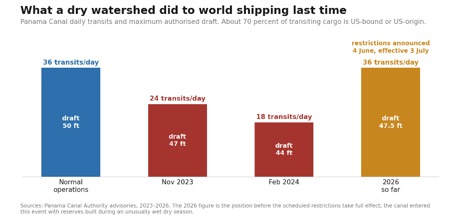
Figure 2. What happened the last time the canal’s watershed ran dry. Daily transits fell from around 36 to 18 between November 2023 and February 2024, with maximum draft cut from 50 feet to 44. Restrictions announced this June take effect from July. The canal entered this event with reserves built during an unusually wet dry season, so a repeat is a risk rather than a schedule.
The Caribbean and the Northern Rim
Beyond the isthmus the same failed rains forecast reaches further than the corridor. FAO puts the probability of below-normal rainfall across the wider Caribbean region at seventy percent, with the highest agricultural drought risk along the Dry Corridor, in Colombia and Venezuela, and across Cuba, the Dominican Republic and Haiti, where roughly six million people are already projected at Crisis or worse. In 2015 and 2016 Haitian harvests in some areas fell by as much as seventy percent and food insecurity doubled within months. Cuba enters this event having effectively run out of diesel dur to U.S. sanctions. The mirror image again holds: Bolivia, Ecuador and Peru are forecast above-average rains.11
South America, Where El Niño Reaches into the Ocean
Off the coast of Peru, El Niño does something it does nowhere else. It stops the deep ocean waters from coming up.
In a normal year, cold water rich in nutrients rises along that coast from the deep, feeds the plankton, and supports the anchovy: the largest single-species fishery on earth. Warm surface water suppresses that upwelling. The plankton fail, and the anchovy disperse, go deep or move south. Peru’s monitoring commission activated a coastal El Niño alert in February and expects the warming to persist into late 2026. The first fishing season of the year opened with a quota of 1.9 million tonnes, the lowest in a decade and 36 percent below last year, and even that was suspended in May and again into June because too much of the catch was juveniles. Fishmeal prices are running more than 75 percent above a year ago. 12
Peru supplies roughly a fifth of the world’s fishmeal and fish oil, which is why this belongs in an article about hunger rather than one about fishing. Fishmeal is protein feed. It goes into salmon farms in Norway and Chile and shrimp ponds across Southeast Asia, and when it becomes scarce buyers move to soybean meal instead, which tightens that market too. The 1997 and 1998 El Niño cut Peruvian fishmeal production to around 815,000 tonnes. The 2023 season was cancelled outright, costing more than $1.4 billion in lost exports and around half a percent of Peru’s national income. 12
Inland, the pattern runs the way it does everywhere else in this article. Northern Brazil, the Amazon basin, Colombia and Venezuela can expect reduced rainfall, higher temperatures, more fire and lower river flow which damages the Amazon forest and its river. In countries that generate much of their electricity from water is a power problem as well as a farming one. 13
Southeastern South America usually does well out of an El Niño. Argentina, Uruguay, Paraguay and southern Brazil tend to get more rain, and that can lift maize and soybean output in some of the largest exporting countries in the world. The same ocean that is emptying Peruvian nets may be filling Argentine grain carts. That comes with a qualification, and not a small one. El Niño is simultaneously Argentine agriculture’s best friend and its worst enemy, and which one depends on strength. Moderate events water the crop; strong events drown it. The same 2015 and 2016 season that produced Argentina’s second-largest soybean harvest on record, 59.1 million tonnes, also damaged more than three million hectares through waterlogging as the Paraná and Uruguay rivers rose. This event is forecast very strong. 14 Whether the world is better or worse fed for this El Niño is not one number. It is a ledger with entries on both sides, and the entries land on different people.
Brazil is not uniformly better off either. The south gains, but Matopiba and the Center-West run drier, and Eduardo Martins of GAAS warns that up to a fifth of national soybean output could be lost if drought settles there. Eduardo Assad of Embrapa is more cautious, putting it nearer ten percent, in line with what 2015 and 2024 actually cost. Even the worse figure would leave 145 to 150 million tonnes and Brazil the largest exporter. October rain decides how big the harvest will be. 14 But soybeans are the wrong crop to worry about. 15
Brazil grows roughly three quarters of its maize as safrinha, the second crop, planted from January into the same fields the soybeans have just left. So the risk to Brazilian maize runs through the soybean harvest rather than around it. Late rains mean late planting, late planting means a late harvest, and a late harvest pushes the safrinha past the safe window into late February and March, to mature through the drying end of the season. The USDA’s Brasília post sets out that sequence explicitly. A record soybean crop that arrives late is not good news for maize. It is the mechanism by which the maize is lost. 16
Two other crops are also exposed, one of them by the rain rather than the lack of it. Brazilian wheat grows in the south, on the wet side of this event, and rain at harvest means sprouting in the head and grain downgraded to animal feed rather than for human consumption; production is already forecast down 22.5 percent to 6.1 million tonnes, pushing imports to a record. Coffee and citrus, flower in September and October in the belt where the outlook shows the risk of drought, which makes the next eight weeks a flowering watch, and a time of worry.17
North America Gets the Other Half of the Deal
Now cross the Rio Grande, and the story inverts.
A strong El Niño splits North American winter weather along a line. The southern tier gets an active Pacific storm track; the northern tier gets a mild, dry one. For the United States that is on balance welcome. NOAA has an El Niño advisory in effect with 97 percent odds the event persists into early spring 2027. The southern track is expected to bring rain to California, the Southwest and the southern Plains, and an exceptional Sierra Nevada snowpack that works as a natural reservoir into summer. Areas of the Southwest that have struggled with persistent drought stand to benefit. The Atlantic hurricane season is suppressed, because El Niño raises the wind shear that tears developing storms apart; in the eastern Pacific it lowers that shear instead, so storms there become more frequent and stronger. The moisture that fed the Grand Canyon flood was drawn inland from a Pacific tropical storm. 18
That is the sentence this series has not yet had occasion to write. In the one part of the world best equipped to absorb a bad year, this El Niño is mostly a good one. Despite that, two days before this article was written, it killed people.
On 29 August a flash flood surged down Bright Angel Creek at the bottom of the Grand Canyon. Two people died, more than sixty were evacuated by air, and the Transcanyon Waterline that supplies the park was destroyed, leaving it on limited reserves. Between half an inch and an inch of rain fell in half an hour onto steep, arid ground. Most of it, in the words of the National Weather Service meteorologist who described it, ran off instantly. The Dragon Bravo burn scar left by last year’s North Rim fire channeled the rest.
The forces behind it were identified quickly: the Arizona monsoon, a marine heatwave, a heat dome pulling moisture inland from a Pacific tropical storm, and this El Niño. Atmospheric moisture over the United States has run five to fifteen percent above normal this summer, and the analysis traced that to record warm Pacific water. Rain lands on ground too hard and too dry to take it, runs off instead of soaking in, and does its damage on the way. 19
The rain the American Southwest needs and the rain that killed two people in a canyon are the same rain.
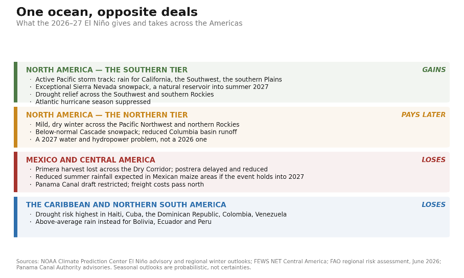
Figure 3. The same event, four different deals. The southern tier of North America gains rain and snowpack; the northern tier pays for it in 2027; Mexico, Central America and the Caribbean lose a harvest. Seasonal outlooks are probabilistic rather than certain.
“The same ocean that is taking a second harvest from a Guatemalan smallholder is filling reservoirs in California. That is not a coincidence in the weather. It is the whole argument of this series in a single season.”
The costs North America does carry are deferred and regional. The Pacific Northwest and the northern Rockies sit on the dry side of the split, and below-normal mountain snowpack in the Cascades and the Columbia basin is a high-confidence outcome. That is a 2027 water and hydropower problem rather than a 2026 one, and it lands on the same wheat country that has already had a hard run. Snowpack is a reservoir that fills in winter and releases slowly through the dry months. A warm winter does not drain it. It causes the snow to fall as rain and stops the snowpack from forming. 20
Mexico is the exception on this side of the border: if the event persists into spring 2027, reduced summer rainfall is expected across its maize belt. And the Midwest has a hazard unrelated to drought, in the March to April transition, where a rapid warm-up followed by a late freeze, the 2016 pattern, threatens early-planted crops and fruit trees. 21
So Where Does American Hunger Come From?
Not from a failed American harvest. It comes from two other places.
The first is price. American shelves are supplied by a global market, and that market is being squeezed at both ends of this article. Central American maize and beans, Asian rice, and the fertilizer that grows all of it are all under pressure at once. A household that buys most of what it eats is exposed to that regardless of how good the Sierra snowpack is.
The second is policy, and it is the one that can still be changed. The 2025 reconciliation law cut SNAP by roughly $187 billion over ten years, extended work requirements to adults aged 55 to 64 and to parents of children aged 14 and over, and for the first time in the program’s sixty-year history required states to share its costs. More than four million people are estimated to have lost benefits between July 2025 and April 2026. The price wave from this El Niño reaches American shops in 2027, into a support system that has just been cut. 22
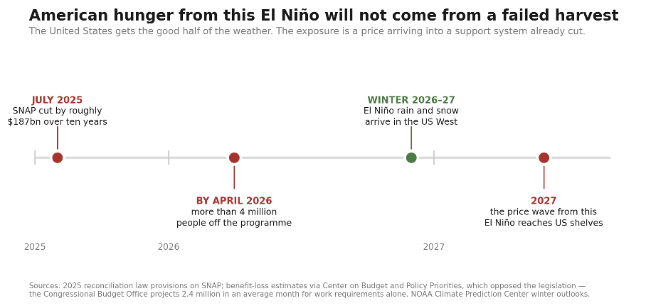
Figure 4. The American sequence. The weather arrives on the helpful side of the split, and the exposure is a price reaching shelves in 2027 into a support program cut in 2025. Benefit-loss estimates come from an organization that opposed the legislation; the Congressional Budget Office’s figure, covering work requirements alone, is lower.
The Part That Already Worked
One more thing belongs here, because it is the only piece of good news in this article and it is load bearing.
During the 2023 and 2024 El Niño, anticipatory action was implemented across nine countries in this region. Cash transfers, agricultural inputs, rehabilitated water systems, irrigation, animal health brigades. It reached more than a hundred thousand people in some 250 rural communities. In several Central American countries, it produced increases of up to forty percent in maize and bean production. 23
That is not relief distributed after a failure. That is more food grown, in the same soil, in the same bad year, because somebody moved before the rain did not come. The corridor has already run the experiment. The postrera is being planted now.
Great writeup, Mark! So many privileged people don't get it.. the innocent poor starve and broil as they squander Earth.
This was a great read, and the Brazil section is where it really clicks for me: pointing out that a record soybean crop arriving late is the mechanism by which the safrinha maize is lost, rather than a separate risk, is the sharpest move in the piece. Most coverage stops at seasonal totals.
What that framing opened up: the same logic is already sitting in your Dry Corridor section. The primera did not just fail on rainfall, it ran late, and the late harvest is one of the reasons FEWS NET expects the postrera to go in delayed and on reduced area. Two very different farming systems, same transmission route, which is timing rather than totals.
If that holds, seasonal rainfall anomaly maps will systematically understate this event, because the loss lives in the shifted calendar. It also sets the deadline on the anticipatory action you describe at the end: it is fixed by the planting window, not by the drought index.